Why You Should Use a Drone For Your Volumetric Surveys
Leading suppliers of excavators and construction equipment across the globe is estimated to be around $113 billion in 2020.
But, providing the machinery and equipment to support an industry, which struggles with inefficiency, would beg the question: Why aren’t most suppliers trying to offer an end-to-end solution?
Companies like Caterpillar, Bobcat, JCB and Terex all supply hardware to leaders within the construction industry, but what can drone technology offer to these companies?
We have already started to see some manufacturing companies embrace this technology and partner with software providers to help with some inefficiencies. And, at the top of the list is managing stockpiles & forecasting, and volumetric surveys.
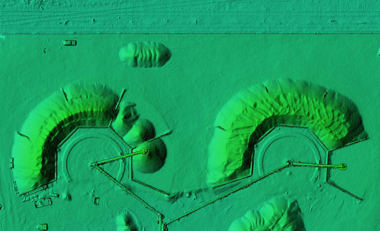
Removing it from the ground is one thing, but managing accurate stock and knowing the volume is key for forecasting and logistics. Traditional surveying methods of stockpile volume calculation rely on site personnel to perform ground surveys with a Global Navigation Satellite Systems — such as GPS — receiver to determine the exact position of each measured point with pinpoint accuracy.
Using drones allows volumetric surveys to be completed in a fraction of the time it takes to conduct conventional surveys, leading to lower costs, higher productivity and improved safety.
By performing volumetric surveys with drones, you will get qualitative and quantitative data supplied in a 3D format, as well as aerial photography and video.
How accurate are volumetric surveys?
Drone surveys are proven to be more accurate than traditional ground surveying methods. And, trusting the calculations are key for site management and accounting.
The measurements and calculations of material is key for multiple reasons:
- Available stock to sell
- Duration of project
- Volumes and resources needed for earthworks extraction etc.
- Forecasting
Companies often perform stockpile inventory on a monthly, quarterly or yearly basis, in order to carry out reporting.
Software providers such as Propeller Aero, Hybird and Pix4d all enable data to be scrutinizsed and converted into real-world context whilest enabling you to pick the important information from it.
LISTEN NOW: Mohamed Hafez of HyBird Technologies discusses capturing the process with UAV data
According to Propeller Aero, the company “creates tools and software for construction companies, mines, quarries, and landfills to collect, process, and visualize accurate survey data. Some of the world’s leading heavy civil and resources operations trust Propeller to answer critical questions about their site’s progress, productivity, work quality, and safety.”
The data collected can also be used within different departments of any organization. New aerial images and 3D models could be used for marketing communications, or to communicate with local authorities about the project.
For companies like Caterpillar, Bobcat, JCB and Terex, to actively promote innovative ways to assist their key customers could see an increase in demand for their own products.
Expert-Level UAS Support
At Consortiq, our UAS team can help you provide this level of service without the major investment of technology and/or platforms.
Our drone pilots can gather the information for you, and they provide the key results and data you need. We also use different software providers, depending on your specific requirement, all while delivering exceptional service.
We recently wrote about the different aspects to consider when making the decision to choose a provider or start an in-house drone program.
Whichever choice you make, it’s important to consult with UAS experts prior to getting started. Experienced consultants will help you to identify your specific needs and explore the best fit to meet those needs. You’ll also get support on creating operations manuals, safety guidelines, and regulation requirements.
No matter what you choose, Consortiq has a solution for you. From unmanned data services that include aerial surveys and mapping, to extensive global remote pilot training and drone consultancy, we’ll help you put the right plan in place.
Need expert-level support? Just complete the form below or call us at 1-855-203-8825 (Americas) or +44 (0)208 0450 322 (Europe) to get started!