Hot Take: Choosing the Right Thermal Imaging Camera for Your Drone

Thermal imaging cameras offer one of the most fascinating technologies available to commercial drone pilots.

These specially designed optics have a wide range of uses, including surveillance, search & rescue, roof inspections, industrial inspections, gas leak detection, and more.

Thermal imaging cameras can significantly expand the capabilities of your existing drone fleet, and can open up new markets when adding drones to your business.

The cost of drone thermal imaging cameras can range from a few thousand to hundreds of thousands of dollars (or pounds). Before committing significant resources, it is essential to remember that not all thermal imaging cameras are created equally.

Depending on the application, certain criteria are more important than others when choosing which thermal imaging camera is best.

To better illustrate the point, the major differences between two thermal imaging cameras will be highlighted.

To establish a fair comparison, two DJI drones will be used, each equipped with a thermal camera made by FLIR.

Specifications to Look For

Before getting into comparisons, there are a few characteristics of thermal cameras worth mentioning.

Often, vendors use thermal resolution as a selling point for a camera’s quality. However, this does not give you enough information to decide whether a given camera is suitable for your needs.

There are important other specifications you will need to consider.

  • IR Resolution: The digital images and videos captured by most drone cameras convert the data they collect into pixels.


Resolution measures how many pixels will be used to generate an image. The higher the resolution, the more pixels used, and the more detail your image will show.


  • Temperature Range: This measurement indicates both the highest and lowest temperatures the thermal camera is able to distinguish.


  • Field of View: The field of view describes how large of an area the camera can see at any one time.


The closer you are to objects, the wider you will need this angle to be. However, if your subject is further away, you can use a camera with a smaller field of view.


  • Focus: Low-end cameras tend to autofocus at the center. Higher-end cameras allow you to choose a custom focal point.


  • Spectral Range: This is the range of wavelengths the camera’s sensor can detect.


Generally, midwave cameras are used for gas leak detection and have a range of 3µm to 5µm. Meanwhile, longwave models, with a range of 8µm to 14µm, are used for nearly all other applications.


  • Radiometric: One of the most important options to consider, thermal cameras that collect radiometric data, capture temperature information for each pixel.


This means you can manipulate the data after your flight. Non-radiometric cameras do not record this information, so there is little benefit to the image after you have flown.

Understanding these options will give you a good idea of which camera is best suited for your needs.

One of the leading manufacturers of thermal cameras for drones, FLIR, offers a great article detailing these characteristics in-depth.

Comparing Thermal Imaging Cameras: Mavic 2 Enterprise Dual & Matrice M210 XT2

Our two DJI drones will be the Mavic 2 Enterprise Dual and the Matrice 210 RTK (M210 RTK), carrying a Zenmuse XT2 camera. For this comparison, only the thermal imaging cameras will be evaluated.

The Mavic uses a FLIR Lepton® thermal microcamera, while the XT2 utilizes the FLIR Tau® 2 thermal microcamera.

The base model of the Mavic 2 Enterprise Dual costs just above $3,000. Without a camera, the M210 RTK is over $10,000.

Depending on which XT2 camera you choose, the cost can range from $5,800 to over $11,000—a considerable price difference.

 So, why would you want to spend so much more on the XT2 when trying to add thermal imaging capabilities to your business?

The unfortunate reality is that, for most applications, the thermal sensor on the Mavic 2 Enterprise Dual is not a good fit, because it does not collect radiometric data.


Thermal imaging camera shot

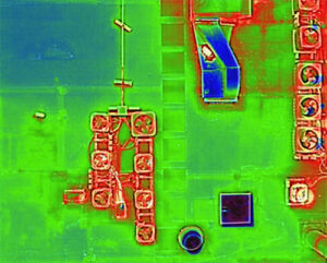
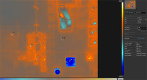
*Figure on the left is the output a saved by the M210 XT2. The figure on the right shows what happens when that image is added to FLIR tools.


Thermal imaging camera shots

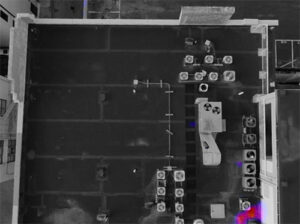
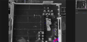
*Figure on the left is from the Mavic 2 Enterprise Dual. The figure on the right shows what happens when the images is added to FLIR tools.


Take a look at the above images – the top is from an M210 XT2, while the bottom is from the Mavic 2 Enterprise Dual. Both shots are from roughly the same height and at the same resolution. As you can see, when added to FLIR tools, the XT2 offers full radiometric data while the Mavic offers none.

While the Mavic 2 Enterprise Dual would work for simple applications such as identifying areas of heat loss on a residential roof, beyond that, the images collected would be useless.

So, Why is Radiometric Data Important?

If you’re hoping to use thermal cameras for industrial inspections, gas leak detection, and most other commercial applications, you radiometric data.

To fully benefit from drone-based thermal cameras, you need the ability to work with data after the flight is complete. Radiometric data offers users the ability to study information at the level of each pixel, a necessity for industrial work.

For most commercial applications, drone thermal camera systems that do not collect radiometric data are simply lacking.

While the cost may seem attractive for lower-end thermal solutions, without this feature, you are likely looking at the wrong tool for the job.

Start with the decision whether or not to collect radiometric data and then compare the other camera specifications to find the best thermal optic for your business’s drone needs.

As the old adage goes, you get what you pay for. High quality thermal imaging cameras do not come cheap.

Not sure which thermal imaging system is right for you? Contact us today by completing the form below or calling us at 1-855-203-8825 (US) or +44 (0)203 290 5762 (UK).

Our experienced team of drone experts will help you make the right decision for your operation!

Picture of David Daly - Contributing Author

David Daly - Contributing Author

David Daly, is an award-winning photographer/writer and licensed (FAA) Commercial sUAS pilot. A graduate of the United States Naval Academy, David is a former Marine Corps officer with a BS in Oceanography and has earned his MBA from the University of Redlands. David has worked for Fortune 100 companies and has a background in aerospace, construction, military/defense, real estate, and technology.

Ready to Integrate Drones Into Your Organization? Contact Us Today to Get Started!

  • This field is for validation purposes and should be left unchanged.